THE SEARCH

** SEARCH HERE ** (if it is 2 or more words put them in quotes)
Custom Search

See how: How to search for your beach across 260+ websites devoted to surfing waves.
The same search box is also at the top of all of our pages on this site.
Why you should use THIS search:
Because any other search includes sites using the mixed metaphor "surfing the web".

Showing posts with label sydney. Show all posts

Actual Sydney Surf from MHL

If you surf in Sydney you must know about the waverider buoy that is read by Manly Hydraulics Laboratory (MHL). Here (and on RealSurf.com) is the link to each day's data which includes the previous three days'' data:
mhl.nsw.gov.au/data/syddir.gif
At first sight the plot does not look easy but with a little study it ends up being both simple and incredibly useful.
Click the graphic for the clues to the information, but note the graphic is for the date 20 November 2011.
Compare that date with the current graphic.

North Steyne Reports

Surf report for the middle of Manly Beach (Sydney - Australia).
A forecast is what is expected to happen, a report is what is actually happening.
Both can be either numbers that you have to work out what they mean or text that give you interpretation of the raw information. Eventually you will just want the numbers.

Go to yosurfer.com for surf reports they also do forecasts.

Manly Hydraulics Lab. (MHL) give up-to-the-minute reports straight from their wave-rider buoys.
Some sites dress up this raw data and make attractive graphics to show the information.
For example here is some of MHLs simplest data, the current temperature of the water at the Sydney wave-rider buoy.

Note: the sea surface temperature should be the same in both of the above graphics.

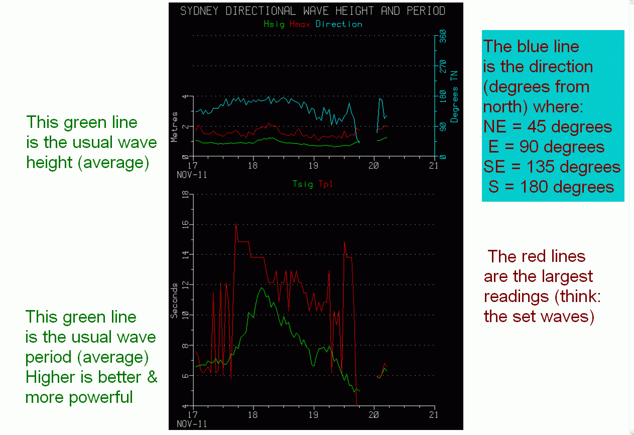
This link is to the more complex MHL data for wave height, period and direction:
mhl.nsw.gov.au/data/syddir.gif
These are the various MHL buoys off the NSW coast:
mhl.nsw.gov.au/www/wave_data_plot.htmlx

Best surfing view (for me)

Look for the Orthographic Projection for SW Pacific (185°W 10°S) of wave height. Also of interest is the one for the period of the wave, the quality of the swell, its period. Longer periods mean that the swell is more powerful. These are called ground swell (wrongly) because they do not relate to the local weather condition.

Wave Watch III Data from
polar.ncep.noaa.gov/waves
NOAA/NCEP Ocean Modelling Branch

one wave at Long Reef

Usual story with wide angle lens, surf look smaller, and it can't show the wave behind when it is facing forward.
Anyway, fun wave and a bit of an obstacle course.

Surf Forecast Australia - La Jolla


Source:
lajollasurf.org/gblpac.html
On this page you can select which part of the world you want to see, actual and forecast data.

Resurrect the Diggers Point project

Years ago there was a proposal to make a classic point break between South Curl Curl and Freshwater beaches in Sydney (Australia).

Can the proponents of this project breathe some life into it by making it available on the web?
Some discussion and some clever ideas could make this project happen.

Surf Forecasts

Global swells explained:
ssurfings.blogspot.com/p/global-swell-animations..
With these graphics you can see where the surf is being generated and how it is moving across the oceans.
Also have a look at
Stormsurf on YouTube

Related sites:

makesurf.net - Making surfing reefs and grooming surf breaks.
kneelupps.info - SUPing but from a kneeling position.
bruce-white.blogspot.com - Bruce's personal blog.
supwindfoil.net - Bruce learns foiling, a blog.

Surf parks?
We recommend if you are looking for information on surf parks and inland surfing you start at:
twitter.com #surfmore